Tag Archives: Locator

Track Your Adventures for Free – Part IV – The Software

This article is Part IV of a series called Track Your Adventures for Free where I outline how to use Ham Radio and your Smartphone as an affordable APRS tracking system.  For reference, here are links to the first 3 parts:

In part III we modified a smartphone headset and our Baofeng UV-5R headset to create an interface between the speaker and microphone of the two devices.  As a refresher, in part I we discussed how APRS works using digital packets that are encoded in analog signals.  The ham radio will receive these analog signals, which are audible to the human ear, and we must get these analog signals to our smartphone so it can decode the digital packets of information that are encoded in the signal.  These packets will contain the APRS position and identification data from transmitting stations.  On the other side of things, our smartphone will also use its internal GPS to determine your current position, and then use this data to create an AX.25 encoded analog signal that it will send to the ham radio to broadcast your position. Great, but how do we accomplish this?

The answer, for Android based smartphones, is to use a piece of software called APRSDroid.  It is available on the Google Play store for $4.99, lifetime updates included via the play store.  However, the developer also provides the software for free on the APRSDroid Website.  You can download the APK to your Android phone and install it outside of the market at no cost to evaluate it.  Just keep in mind that because it was installed manually, updates will not come via the Google Play store like other apps.  You will have to keep track of new releases as they come out and manually install them.  I recommend purchasing the app once you have evaluated it and made sure it works out for you simply to support the developer in his great work and also to ensure you always have the latest version.

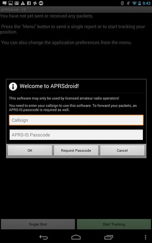
After you install the application either manually or purchasing it on the Play Store, open the application and you will be greeted with the following:

APRSdroid Start

For many of you, this will probably be the first time you hear about APRS-IS.  APRS-IS (Automatic Packet Reporting System-Internet Service) is the common name given to the Internet-based network which inter-connects various APRS radio networks throughout the world (and space). APRS-IS is maintained and operated by volunteer Amateur Radio operators to provide world-wide capabilities to the Amateur Radio APRS RF networks and to promote the Amateur Radio service as a whole.  Because you will be injecting information into the APRS-IS system, which is designed for licensed amateur radio operators (Hams), you must be properly identified to obtain the privilege.  Assuming you do not already have an APRS-IS passcode, you should click on the “Request Passcode” link to continue.

Continue reading Track Your Adventures for Free – Part IV – The Software

Track Your Adventures for Free – Part II – The Hardware

In Part I of Track Your Adventures for Free, I made mention of using APRS as a tracking system at a much lower cost than APRS ready radios such as the Yaesu FTM-400DR and the popular Kenwood TM-D710A that are upwards of $500 for the radio alone.  These radios are exceptional, a beautiful rendition of hardware, but unnecessary.  What makes them uniquely suited for APRS is that they have GPS capability to determine your position, and they also have a built in TNC (Terminal Node Controller), which is essentially in charge of converting your digital data into an analog audio tone representation of that data using the AX.25 protocol.  It serves as a modem allowing you to transmit your digital position data obtained from the GPS, and also decodes the AX.25 coded tones that arrive from other users and converts them to digital data on receive.  Other functions are supported, such as messaging, but we can discuss those features as we progress.

While a TNC might seem complicated, it is a rather simple and primitive device in comparison to today’s technology.  Our smartphones are millions of times more capable, and this is what we will be taking advantage of.  With the Yaesu and Kenwood radios, you still have to connect to an external device if you want to see the position data on a map.  This is usually done by connecting it to an expensive GPS unit for mapping (only a limited set are supported), or to a smartphone/computer running mapping software.  Using a smartphone or computer to also perform the TNC function therefore seems logical.

To summarize, what you need for APRS is:

  1. A radio capable of transmitting and receiving in the 2 meter (144MHz) ham band (highly recommend one that supports VOX [voice activated transmission]).
  2. A GPS receiver.
  3. A device that can serve as a TNC to convert your GPS data into an audio signal
  4. A way to connect your TNC device to your radio
  5. Ideally, a device that can put position data on a map to help you visualize where APRS users are relative to you, and also display messages and allow you to compose messages if you choose to use that feature.

That’s it.  If you get these 5 items, you are ready for APRS.  What most people don’t realize is that a smartphone is capable of doing 2, 3, and 5.  So what’s left? A radio, and a way to connect your smartphone to your radio. So lets look at the simplest solution:

Continue reading Track Your Adventures for Free – Part II – The Hardware

Track Your Adventures for Free

Adventures are meant to be shared! But for those of us in the Overland community, our adventures often take us to places where there is no voice or data reception.  While smartphones have the ability to beacon your position to share with friends and family back home, they are only as effective as your carrier’s coverage area.  Most people make the switch to a satellite based tracking device such as the SPOT Connect or InReach to fill this void.  However, these devices require that you pay a subscription for both their emergency beaconing features, and an additional fee if you want to track your travels.  This isn’t always cost effective, and comes with several limitations.

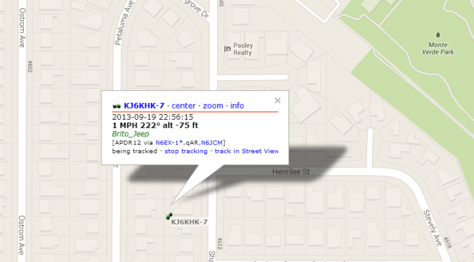
A trend we see among the Overland community is that most are licensed ham radio operators or have plans to become licensed.  Those who are licensed can take advantage of the Automatic Packet Reporting System (APRS) that is deployed all over the world through a network of volunteer ham radio operators and organizations.  APRS is a digital communication system designed to support several tactical communication objects, one of which is Global Position System (GPS) data.  The network is formed by a collaborative deployment of digital repeaters (digipeaters) that listen for packet data on the designated local APRS frequency.  In North America, that frequency is 143.390 MHz, and if you tune your radio to that frequency you will hear the AX.25 protocol frames being transmitted much like an old modem or fax machine sound.  The digipeters listen for local signals and re-transmit them at a higher power to propagate them over long distances much like a traditional voice repeater works.  However, APRS packets can go through a specified number of hops through various digipeters, and this is selectable via the “PATH” instruction in your digital packet.  Using PATH, you decide how far your actual transmitted signal is physically repeated on the network. This gives you some control over how your position beacon packets propagate.  Most importantly, your packet will usually hit an APRS Internet Gate (known as an iGate) that will connect to the APRS Internet System (APRS-IS).  APRS-IS is the reason why you are able to share your data with others, because your position packet data is then available on the aprs.fi website and that information can be accessed accross the world by anyone with an internet connection and who knows your call sign.  It is important to note that APRS does not require the internet, that is just a bonus. It can work from radio-to-radio, allowing groups to track each other real-time.  This again, highlights the use of PATH because of the geographical location of your group members.  If you are all within 50 miles of each other, then a single digipeter transmission should cover your group, but if one is 100 miles away you would want to increase your PATH to ensure that your radio waves reach their particular radio.

Continue reading Track Your Adventures for Free